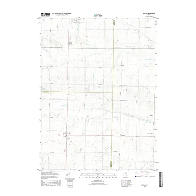
2016 Map of Sullivan
USGS Topo · Published 2016About this map
Sullivan and Huntington anchor this agricultural landscape in north-central Ohio, situated where Ashland Co meets Lorain Co and Medina Co. The terrain is defined by the winding course of the E Br Black River and its various tributaries like Wellington Cr and Coon Cr, which drain a patchwork of family farms and timbered tracts. For genealogists, the map is particularly detailed regarding local burial grounds, including the West Main Street Cem and Southview Cem near Sullivan, and the more isolated Marsh Cem and Gould Cem to the south.
Find a feature on this map
58 named features on this map. Tap any name to fly to it.
Don’t see what you’re looking for? This feature index may not catch every label — zoom into the map to look around manually.
Map Details
Editions of this 2016 Sullivan Map
This is the sole edition of this map. No revisions or reprints were ever made.
Other maps of this area

1904 · Wellington
USGS Topo · 1:62,500

1906 · Wellington
USGS Topo · 1:62,500

1906 · West Salem
USGS Topo · 1:62,500

1908 · Ashland
USGS Topo · 1:62,500

1908 · West Salem
USGS Topo · 1:62,500

1908 · New London
USGS Topo · 1:62,500

1950 · Marion
USGS Topo · 1:250,000

1956 · Toledo
USGS Topo · 1:250,000
1960 · Wellington
USGS Topo · 1:24,000

1960 · Nova
USGS Topo · 1:24,000