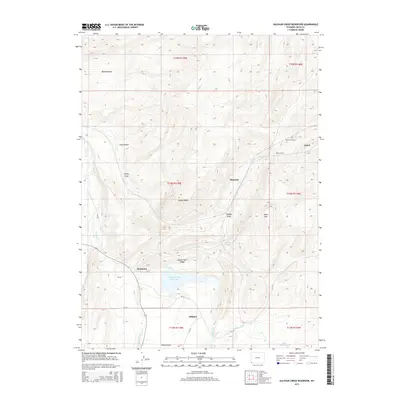
2015 Map of Sulphur Creek Reservoir
USGS Topo · Published 2015About this map
Sulphur Creek Reservoir sits at the heart of this high-country drainage, where the waters of Sulphur Creek and LaChapelle Creek meet. This Uinta County landscape is defined by its transit history, particularly the infrastructure of the railroad. The presence of the Altamont Tunnel and Aspen Tunnel through the eastern ridges reveals the engineering required to navigate the local terrain. Small settlements like Aspen, Altamont, and Beartown are scattered among geographic landmarks such as Oyster Shell Ridge and Knight Ridge. To the south, Hilliard anchors the wide expanse of Hilliard Flat, while the western edge is traced by the Bear River. The map provides a clear look at the network of county roads, including CR-159, that connect these remote high-desert outposts and ranching lands.
Find a feature on this map
37 named features on this map. Tap any name to fly to it.
Don’t see what you’re looking for? This feature index may not catch every label — zoom into the map to look around manually.
Map Details
Editions of this 2015 Sulphur Creek Reservoir Map
This is the sole edition of this map. No revisions or reprints were ever made.
Other maps of this area

1954 · Ogden
USGS Topo · 1:250,000

1958 · Ogden
USGS Topo · 1:250,000

1960 · Ogden
USGS Topo · 1:250,000

1965 · Evanston
USGS Topo · 1:24,000

1965 · Ragan
USGS Topo · 1:24,000

1965 · Myers Reservoir
USGS Topo · 1:24,000

1965 · Sulphur Creek Reservoir
USGS Topo · 1:24,000

1965 · Guild Hollow
USGS Topo · 1:24,000
1965 · Pine Knoll
USGS Topo · 1:24,000
1965 · Moslander Reservoir
USGS Topo · 1:24,000