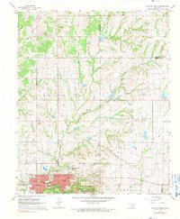
1967 Map of Sulphur North
USGS Topo · Published 1990About this map
Sulphur and its immediate northern landscape are captured here in the late 1960s, showing a transition from the structured street grid of the town to the rolling hills of the Fitzhugh and Leeper regions. The southern edge of the map highlights the proximity of Platt National Park to the urban center, where a Power Plant and the Sulphur Airport serve the local community. For genealogists and local historians, the sheet preserves the locations of several community landmarks, including Washington Sch, Cameron Sch, and the Oaklawn Cemetery. The St Louis San Francisco railroad and numerous water features like Rock Creek and Tall Crest Lake illustrate the local topography and industrial infrastructure. To the north, the smaller settlement of Oak Grove stands near the headwaters of Hogskin Creek, while several Gravel Pits indicate active extraction operations during this era.
Find a feature on this map
36 named features on this map. Tap any name to fly to it.
Don’t see what you’re looking for? This feature index may not catch every label — zoom into the map to look around manually.
Map Details
Editions of this 1967 Sulphur North Map
3 editions found
Other maps of this area

1898 · Pauls Valley
USGS Topo · 1:125,000

1901 · Stonewall
USGS Topo · 1:125,000

1901 · Tishomingo
USGS Topo · 1:125,000

1901 · Ardmore
USGS Topo · 1:125,000

1902 · Pauls Valley
USGS Topo · 1:125,000

1918 · Ardmore
USGS Topo · 1:125,000

1957 · Ardmore
USGS Topo · 1:250,000

1963 · Ardmore
USGS Topo · 1:250,000

1963 · Sulphur South
USGS Topo · 1:24,000

1963 · Mill Creek
USGS Topo · 1:24,000