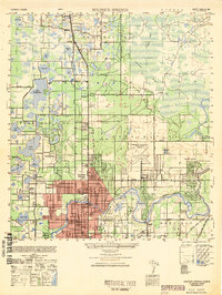
1949 Map of Sulphur Springs
USGS Topo · Published 1949About this map
The Hillsborough River winds through the southeastern portion of this landscape, anchoring the developing communities of Sulphur Springs and Temple Terrace. This late-1940s survey reveals a transition from the urban density of Tampa in the south toward a lake-dotted interior to the north. Extensive rail infrastructure, including the Seaboard Air Line and Atlantic Coast Line, services the region, while the Henderson-Hillsborough International Airport occupies a significant footprint in the central east.
Find a feature on this map
62 named features on this map. Tap any name to fly to it.
Don’t see what you’re looking for? This feature index may not catch every label — zoom into the map to look around manually.
Map Details
Editions of this 1949 Sulphur Springs Map
This is the sole edition of this map. No revisions or reprints were ever made.
Other maps of this area

1921 · Tampa
USGS Topo · 1:62,500

1921 · St Petersburg
USGS Topo · 1:62,500

1943 · Gandy Bridge
USGS Topo · 1:31,680

1943 · Odessa
USGS Topo · 1:24,000

1943 · Thonotosassa
USGS Topo · 1:24,000

1943 · Lutz
USGS Topo · 1:24,000

1944 · Sulphur Springs
USGS Topo · 1:31,680

1944 · Mango
USGS Topo · 1:31,680

1944 · Tampa
USGS Topo · 1:31,680

1944 · Wesley Chapel
USGS Topo · 1:31,680