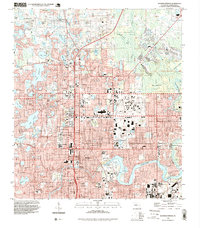
1995 Map of Sulphur Springs
USGS Topo · Published 1999About this map
The Hillsborough River snakes through this suburban landscape north of Tampa, defining the geography of neighborhoods like Sulphur Springs and Temple Terrace. By the mid-1990s, the area had transitioned into a dense residential and academic hub, anchored by the sprawling campus of the University of Southern Florida and the world-renowned Busch Gardens. The map reveals an intricate network of water bodies, from Lake Carroll to the smaller Egypt Lake, which are integrated into the neighborhood fabric. Pockets of local history remain visible in the placement of the Shady Grove Cemetery, Country Cem, and the Hamner Lookout Tower. Significant civic infrastructure is represented by the County Hospital and numerous schools like Most Holy Redeemer Sch and Chamberlain Sch, reflecting the postwar development boom that transformed these citrus-growing regions into the metropolitan core of Hillsborough County.
Find a feature on this map
76 named features on this map. Tap any name to fly to it.
Don’t see what you’re looking for? This feature index may not catch every label — zoom into the map to look around manually.
Map Details
Editions of this 1995 Sulphur Springs Map
This is the sole edition of this map. No revisions or reprints were ever made.
Other maps of this area

1921 · Tampa
USGS Topo · 1:62,500

1921 · St Petersburg
USGS Topo · 1:62,500

1943 · Gandy Bridge
USGS Topo · 1:31,680

1943 · Odessa
USGS Topo · 1:24,000

1943 · Thonotosassa
USGS Topo · 1:24,000

1943 · Lutz
USGS Topo · 1:24,000

1944 · Sulphur Springs
USGS Topo · 1:31,680

1944 · Mango
USGS Topo · 1:31,680

1944 · Tampa
USGS Topo · 1:31,680

1944 · Wesley Chapel
USGS Topo · 1:31,680