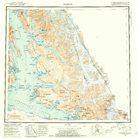
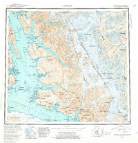
1952 Map of Sumdum
USGS Topo · Published 1953About this map
The Tongass National Forest dominates this coastal landscape, where deep glacial fjords carve into the mainland of the First Judicial Division. Along the shoreline of Stephens Passage and Frederick Sound, small outposts like Indian Village and the settlement of Windham represent the human footprint in an area otherwise defined by massive ice fields and steep peaks. The resource-driven nature of the region is evident in the presence of the Crystal Mine and the Chuck Mining Camp, both located near the protected waters of Windham Bay and the Chuck River. These sites suggest a history of prospecting amidst the dramatic geography of Mt Sumdum and the Sumdum Glacier. Deep inland reaches such as Tracy Arm and Endicott Arm terminate at the massive faces of the South Sawyer Glacier and Dawes Glacier, illustrating the maritime routes essential for navigating this labyrinth of water and ice during the early 1950s.
Find a feature on this map
128 named features on this map. Tap any name to fly to it.
Don’t see what you’re looking for? This feature index may not catch every label — zoom into the map to look around manually.
Map Details
Editions of this 1952 Sumdum Map
6 editions found

Other maps of this area

1943 · Sumdum B-4
USGS Topo · 1:63,360

1948 · Sitka D-1
USGS Topo · 1:63,360

1948 · Sitka B-1
USGS Topo · 1:63,360

1948 · Sumdum A-4
USGS Topo · 1:63,360

1948 · Sitka C-1
USGS Topo · 1:63,360

1948 · Sumdum D-6
USGS Topo · 1:63,360

1948 · Sumdum A-5
USGS Topo · 1:63,360

1948 · Sumdum C-5
USGS Topo · 1:63,360

1948 · Sumdum A-6
USGS Topo · 1:63,360

1948 · Sumdum B-6
USGS Topo · 1:63,360