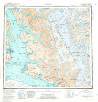
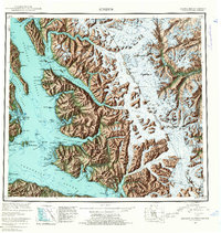
1952 Map of Sumdum
USGS Topo · Published 1961About this map
The Tongass National Forest dominates this mid-century survey of the Southeast Alaska coastline, where massive ice fields meet the complex waterways of the Alexander Archipelago. Deep glacial fjords like Tracy Arm and Endicott Arm reach into the mainland, fed by the Sawyer Glacier and Dawes Glacier. Along the shoreline of Stephens Passage and Holkham Bay, small settlements and industrial outposts tell a story of remote extraction, including Sumdum and the Chuck Mining Camp. To the north, the Crystal Mines are positioned near Port Snettisham, while the interior is marked by the high peaks of the Endicott Mountains. The international border with British Columbia is defined by a series of surveyed points such as Boundary Peak 76, cutting through the ice-covered heights of the Baird Glacier and the Chutine River drainage. This map captures the region when small settlements like Indian Village and Windham were the primary human anchors in a landscape dominated by tide-water glaciers.
Find a feature on this map
105 named features on this map. Tap any name to fly to it.
Don’t see what you’re looking for? This feature index may not catch every label — zoom into the map to look around manually.
Map Details
Editions of this 1952 Sumdum Map
6 editions found

Other maps of this area

1943 · Sumdum B-4
USGS Topo · 1:63,360

1948 · Sitka D-1
USGS Topo · 1:63,360

1948 · Sitka B-1
USGS Topo · 1:63,360

1948 · Sumdum A-4
USGS Topo · 1:63,360

1948 · Sitka C-1
USGS Topo · 1:63,360

1948 · Sumdum D-6
USGS Topo · 1:63,360

1948 · Sumdum A-5
USGS Topo · 1:63,360

1948 · Sumdum C-5
USGS Topo · 1:63,360

1948 · Sumdum A-6
USGS Topo · 1:63,360

1948 · Sumdum B-6
USGS Topo · 1:63,360