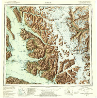
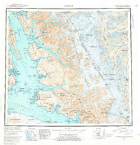
1952 Map of Sumdum
USGS Topo · Published 1954About this map
Indian Village and the small settlements of Sumdum and Windham anchor this mid-century topographic record of the Alaskan panhandle. The landscape is defined by the massive ice fields and active tidewater glaciers of the Tongass National Forest, where the South Sawyer Glacier and Dawes Glacier meet the deep fjords of Tracy Arm and Endicott Arm. The map documents the industrial and cultural footprint of the era, from the Chuck Mining Camp near Windham Bay to Jamestown on the shores of Port Houghton.
Find a feature on this map
110 named features on this map. Tap any name to fly to it.
Don’t see what you’re looking for? This feature index may not catch every label — zoom into the map to look around manually.
Map Details
Editions of this 1952 Sumdum Map
6 editions found

Other maps of this area

1943 · Sumdum B-4
USGS Topo · 1:63,360

1948 · Sitka D-1
USGS Topo · 1:63,360

1948 · Sitka B-1
USGS Topo · 1:63,360

1948 · Sumdum A-4
USGS Topo · 1:63,360

1948 · Sitka C-1
USGS Topo · 1:63,360

1948 · Sumdum D-6
USGS Topo · 1:63,360

1948 · Sumdum A-5
USGS Topo · 1:63,360

1948 · Sumdum C-5
USGS Topo · 1:63,360

1948 · Sumdum A-6
USGS Topo · 1:63,360

1948 · Sumdum B-6
USGS Topo · 1:63,360