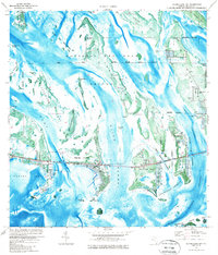
1972 Map of Summerland Key
USGS Topo · Published 1986About this map
The National Key Deer Refuge dominates the landscape of these lower Florida keys, where the terrestrial environment is defined by dense mangroves and scattered hammocks. Development in the early 1970s is concentrated along the corridor of U. S. Highway No 1, which links Summerland Key and Ramrod Key to the larger islands. On Summerland Key, a small Landing Strip and Quarry indicate the specialized infrastructure supporting this isolated island community.
Find a feature on this map
37 named features on this map. Tap any name to fly to it.
Don’t see what you’re looking for? This feature index may not catch every label — zoom into the map to look around manually.
Map Details
Editions of this 1972 Summerland Key Map
2 editions found

Other maps of this area

1921 · Sugar Loaf Key
USGS Topo · 1:62,500

1943 · Saddlebunch Keys
USGS Topo · 1:24,000

1943 · Sugarloaf Key
USGS Topo · 1:24,000

1968 · Saddlebunch Keys
USGS Topo · 1:24,000

1972 · Big Pine Key
USGS Topo · 1:24,000

1972 · Loggerhead Key
USGS Topo · 1:24,000

1972 · Sawyer Key
USGS Topo · 1:24,000

1972 · Horseshoe Keys
USGS Topo · 1:24,000

1972 · Content Keys
USGS Topo · 1:24,000
1972 · Saddlebunch Keys
USGS Topo · 1:24,000