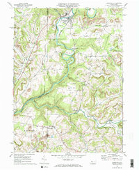
1969 Map of Summerville
USGS Topo · Published 1984About this map
Redbank Creek carves through the undulating landscape of Jefferson and Clarion counties, defining the early development of Summerville and nearby Heathville. By the late 1960s, this area reflects a complex layering of industrial history, where the Penn Central and Pittsburg and Shawmut railroads supported local extraction. Numerous Gas Wells are scattered across the townships of Clover, Beaver, and Redbank, illustrating the persistent energy economy of the region.
Find a feature on this map
51 named features on this map. Tap any name to fly to it.
Don’t see what you’re looking for? This feature index may not catch every label — zoom into the map to look around manually.
Map Details
Editions of this 1969 Summerville Map
3 editions found
Other maps of this area

1901 · Rural Valley
USGS Topo · 1:62,500

1903 · Rural Valley
USGS Topo · 1:62,500

1906 · Clarion
USGS Topo · 1:62,500

1907 · Clarion
USGS Topo · 1:62,500

1909 · Smicksburg
USGS Topo · 1:62,500

1924 · Brookville
USGS Topo · 1:62,500

1926 · Brookville
USGS Topo · 1:62,500

1938 · Smicksburg
USGS Topo · 1:62,500

1939 · Smicksburg
USGS Topo · 1:62,500

1944 · Brookville
USGS Topo · 1:62,500