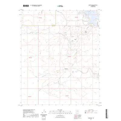
2023 Map of Sumner Dam
USGS Topo · Published 2023About this map
The Pecos River carves a deep valley through this landscape on the border of De Baca and Guadalupe counties. At the northern edge, the waters of Lake Sumner meet the river, surrounded by a network of recreation-oriented roads like Westside Campground Loop and Eastside Campground Rd. The small settlements of Salado and Guadalupe are central to the river’s western banks, each anchored by their respective burial grounds, the Salado Creek Cem and Guadalupe Cem. This topography is defined by seasonal drainages like Salado Creek, Guadalupe Arroyo, and Tigre Arroyo, which cut through the high plains toward the riverbed. The presence of local names like Old Cabin Pl and Settlers Pl reflects the enduring ranching and rural residential character of this high-desert region south of the dam.
Find a feature on this map
32 named features on this map. Tap any name to fly to it.
Don’t see what you’re looking for? This feature index may not catch every label — zoom into the map to look around manually.
Map Details
Editions of this 2023 Sumner Dam Map
This is the sole edition of this map. No revisions or reprints were ever made.
Other maps of this area

1954 · Fort Sumner
USGS Topo · 1:250,000

1958 · Fort Sumner
USGS Topo · 1:250,000

1965 · Fort Sumner West
USGS Topo · 1:24,000

1965 · Windmill Draw
USGS Topo · 1:24,000

1966 · Gibbons Ranch
USGS Topo · 1:24,000

1966 · Ricardo
USGS Topo · 1:24,000

1966 · Ojo Negro Creek
USGS Topo · 1:24,000

1966 · Alamogordo Dam
USGS Topo · 1:24,000

1966 · Cooper Ranch
USGS Topo · 1:24,000

1966 · Colorado Canyon
USGS Topo · 1:24,000