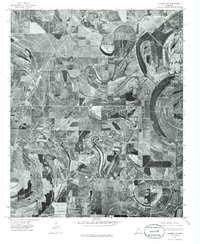
1974 Map of Sumner NW
USGS Topo · Published 1986About this map
Quiver River meanders in tight, dramatic oxbows across this 1974 orthophoto, revealing the intensive agricultural patterns of the Mississippi Delta. This aerial perspective, captured by the Geological Survey, provides a clear view of the rural landscape before modern development altered these traditional field boundaries. The small settlement of Rome sits along the western edge, positioned near the rail-aligned corridor that defined many Delta towns. Further south, the map includes a portion of Parchman, offering a stark visual record of the land use associated with this localized geography. The stark contrast between the wooded riverbanks and the vast, geometric clearings of the surrounding farmland illustrates the complete transformation of the alluvial plain into a productive agricultural engine.
Find a feature on this map
3 named features on this map. Tap any name to fly to it.
Don’t see what you’re looking for? This feature index may not catch every label — zoom into the map to look around manually.
Map Details
Editions of this 1974 Sumner NW Map
2 editions found
Other maps of this area

1931 · Sumner
USGS Topo · 1:48,000

1931 · Drew
USGS Topo · 1:48,000

1932 · Tutwiler
USGS Topo · 1:48,000

1935 · Clarksdale
USGS Topo · 1:62,500

1935 · Sumner
USGS Topo · 1:62,500

1935 · Tutwiler
USGS Topo · 1:62,500

1935 · Mound Bayou
USGS Topo · 1:62,500

1939 · Sumner
USGS Topo · 1:62,500

1939 · Tutwiler
USGS Topo · 1:62,500

1939 · Clarksdale
USGS Topo · 1:62,500