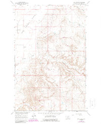
1965 Map of Sun Prairie
USGS Topo · Published 1987About this map
The Sun Prairie Flats dominate the northwestern landscape of this Phillips County survey, illustrating the characteristic topography of the Missouri River Basin development area. The small settlement of Sun Prairie serves as a focal point for the region, anchored by the Sun Prairie Sch situated along the open plains. This 1965 record, updated with 1980s aerial data, reveals a network of intermittent watercourses that carve through the prairie, including Telegraph Creek and Dog Creek. These drainages, along with the Box Elder Coulee in the north and Box Elder Creek to the south, define the erosion patterns and land use in this part of Montana. The map provides a precise look at the section lines and unimproved dirt roads that connected isolated homesteads and schoolhouses during the mid-20th century.
Find a feature on this map
9 named features on this map. Tap any name to fly to it.
Don’t see what you’re looking for? This feature index may not catch every label — zoom into the map to look around manually.
Map Details
Editions of this 1965 Sun Prairie Map
3 editions found
Other maps of this area

1954 · Jordan
USGS Topo · 1:250,000

1956 · Jordan
USGS Topo · 1:250,000

1958 · Jordan
USGS Topo · 1:250,000

1964 · Jordan
USGS Topo · 1:250,000

1965 · Coal Mine Hill
USGS Topo · 1:24,000

1965 · Sun Prairie
USGS Topo · 1:24,000

1965 · Herman Point
USGS Topo · 1:24,000

1965 · Whitcomb Lake
USGS Topo · 1:24,000
1965 · Stratton Reservoir
USGS Topo · 1:24,000

1965 · Schuyler Butte
USGS Topo · 1:24,000