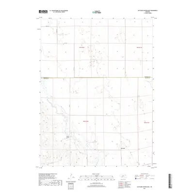
2017 Map of Suttlers Canyon East
USGS Topo · Published 2017About this map
Red Willow Cr carves a path through the southwestern portion of this Nebraska landscape, where the terrain transitions into the distinct landform of Suttlers Canyon. The area is defined by its rural layout, straddling the border between Lincoln and Hayes Counties. The small settlement of Marengo serves as a localized hub in the southeast, connected to the surrounding countryside by a network of sectional roads. These thoroughfares, including Brushy Rd in the north and Rd 746 near the canyon, follow the grid of the Public Land Survey System. The map documents the persistent agricultural character of this region, showing how the land is divided into townships such as t8n r32w and t9n r31w, with the winding creek providing the primary natural drainage across the otherwise structured prairie sections.
Find a feature on this map
18 named features on this map. Tap any name to fly to it.
Don’t see what you’re looking for? This feature index may not catch every label — zoom into the map to look around manually.
Map Details
Editions of this 2017 Suttlers Canyon East Map
This is the sole edition of this map. No revisions or reprints were ever made.
Other maps of this area

1954 · McCook
USGS Topo · 1:250,000

1956 · White NE
USGS Topo · 1:24,000

1956 · Dickens
USGS Topo · 1:24,000

1956 · Somerset
USGS Topo · 1:24,000

1957 · McCook
USGS Topo · 1:250,000

1958 · McCook
USGS Topo · 1:250,000

1973 · Camp Hayes Lake SE
USGS Topo · 1:24,000

1973 · Suttlers Canyon East
USGS Topo · 1:24,000

1973 · Suttlers Canyon West
USGS Topo · 1:24,000
1973 · Melton Ranch Airport
USGS Topo · 1:24,000