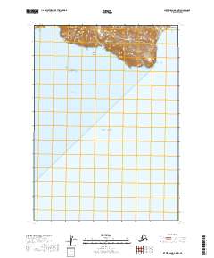
2019 Map of Sutwik Island B-6 NW
USGS Topo · Published 2019About this map
Cape Kumliun dominates the northern coast of this maritime study, where the foothills of the Aleutian Range meet the cold waters of the Pacific Ocean. This coastal segment of the Alaska Peninsula is defined by its dramatic relief and isolation, centered on the protected waters of Chignik Bay. The terrain rises sharply from the shoreline toward mountainous peaks, with small drainage systems like Kumliun Cr cutting through the ridges. To the west, Gull Island stands as a distinct landmark in the bay, marking a landscape largely shaped by geological forces and the sea. The map reveals the stark intersection of high-elevation tundra and the open ocean at the edge of the continent.
Find a feature on this map
13 named features on this map. Tap any name to fly to it.
Don’t see what you’re looking for? This feature index may not catch every label — zoom into the map to look around manually.
Map Details
Editions of this 2019 Sutwik Island B-6 NW Map
This is the sole edition of this map. No revisions or reprints were ever made.
Other maps of this area

1951 · Sutwik Island
USGS Topo · 1:250,000

1963 · Chignik B-1
USGS Topo · 1:63,360

1963 · Chignik C-1
USGS Topo · 1:63,360

1963 · Sutwik Island B-6
USGS Topo · 1:63,360

1963 · Sutwik Island
USGS Topo · 1:250,000

1963 · Sutwik Island C-6
USGS Topo · 1:63,360

1963 · Chignik
USGS Topo · 1:250,000
2019 · Sutwik Island B-6 NE
USGS Topo · 1:25,000
2019 · Sutwik Island B-6 SE
USGS Topo · 1:25,000
2019 · Sutwik Island B-6 SW
USGS Topo · 1:25,000