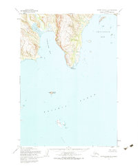
1954 Map of Sutwik Island D-3
USGS Topo · Published 1983About this map
Nakalilok Bay and the jagged southern coastline of the Alaska Peninsula define this 1954 survey. The map details a maritime landscape of extreme transitions, from the steep Cliff and high Cascade near Nakol to the expansive Tidal Flat at the head of the bay. Navigation and coastal activity are evident through the identification of Nakolilok E Base and various Cabins located on remote islands like Ugaiushak Island. This topographic study, compiled from 1953 aerial photography and USC&GS hydrographic data, captures the geographical nuances of Cape Kuyuyukak and the hazards of Chiginagak Bay, including Logan Reef and several areas marked foul. Farther offshore, Central Island and several smaller islets emphasize the isolation of this Pacific coastline during the mid-twentieth century.
Find a feature on this map
18 named features on this map. Tap any name to fly to it.
Don’t see what you’re looking for? This feature index may not catch every label — zoom into the map to look around manually.
Map Details
Editions of this 1954 Sutwik Island D-3 Map
2 editions found
Other maps of this area

1943 · Ugashik
USGS Topo · 1:250,000

1948 · Ugashik
USGS Topo · 1:250,000

1949 · Ugashik
USGS Topo · 1:250,000

1951 · Sutwik Island
USGS Topo · 1:250,000

1951 · Ugashik A-2
USGS Topo · 1:63,360

1954 · Ugashik A-3
USGS Topo · 1:63,360

1954 · Sutwik Island D-3
USGS Topo · 1:63,360

1963 · Ugashik A-4
USGS Topo · 1:63,360
1963 · Sutwik Island C-4
USGS Topo · 1:63,360

1963 · Sutwik Island
USGS Topo · 1:250,000