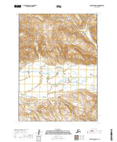
2019 Map of Sutwik Island D-6 SE
USGS Topo · Published 2019About this map
Aniakchak National Preserve encompasses most of this landscape, dominated by the winding path of the Aniakchak Wild and Scenic River. The terrain is characterized by dramatic elevation changes, with the Aniakchak River cutting through the center of the survey area. In the southwestern reaches, the Albert Johnson Cr joins the drainage system, illustrating the complex hydrology of the Alaska Peninsula. This 2019 survey documents the primitive state of the preserve, where no roads or established settlements are marked, emphasizing the area's role as a protected wilderness. The map provides a detailed view of the township and range divisions, including t39s r53w and t39s r54w, which define the administrative boundaries within this remote coastal region.
Find a feature on this map
11 named features on this map. Tap any name to fly to it.
Don’t see what you’re looking for? This feature index may not catch every label — zoom into the map to look around manually.
Map Details
Editions of this 2019 Sutwik Island D-6 SE Map
This is the sole edition of this map. No revisions or reprints were ever made.
Other maps of this area

1951 · Sutwik Island
USGS Topo · 1:250,000

1963 · Sutwik Island
USGS Topo · 1:250,000

1963 · Sutwik Island C-6
USGS Topo · 1:63,360
1963 · Sutwik Island C-5
USGS Topo · 1:63,360
1963 · Sutwik Island D-5
USGS Topo · 1:63,360
1963 · Sutwik Island D-6
USGS Topo · 1:63,360
2019 · Sutwik Island D-5 NW
USGS Topo · 1:25,000
2019 · Sutwik Island D-6 SW
USGS Topo · 1:25,000
2019 · Sutwik Island D-6 NE
USGS Topo · 1:25,000
2019 · Sutwik Island C-5 NW
USGS Topo · 1:25,000