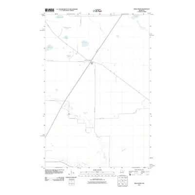
2010 Map of Swan River
USGS Topo · Published 2010About this map
The Swan River flows through this northern landscape, winding past the community of Swan River and the local Swan River Post Office. This 2010 topographic record documents a region defined by its numerous water bodies and drainage systems, including Hudson Lake, Bullhead Lake, and the distinctly named Pancake Lake. These glacial lakes are connected by a network of small waterways like Bruce Creek and the West Branch Floodwood River.
Find a feature on this map
24 named features on this map. Tap any name to fly to it.
Don’t see what you’re looking for? This feature index may not catch every label — zoom into the map to look around manually.
Map Details
Editions of this 2010 Swan River Map
This is the sole edition of this map. No revisions or reprints were ever made.
Other maps of this area

1953 · Duluth
USGS Topo · 1:250,000

1954 · Hibbing
USGS Topo · 1:250,000

1957 · Hibbing
USGS Topo · 1:250,000

1958 · Hibbing
USGS Topo · 1:250,000

1958 · Duluth
USGS Topo · 1:250,000

1964 · Hibbing
USGS Topo · 1:250,000

1969 · Wawina
USGS Topo · 1:24,000
1969 · Floodwood Lake
USGS Topo · 1:24,000
1969 · Goodland
USGS Topo · 1:24,000

1969 · Island
USGS Topo · 1:24,000