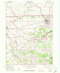
1960 Map of Swanton
USGS Topo · Published 1972About this map
The Indian Treaty Boundary cuts across the southern portion of this landscape, marking a legacy of early land divisions near the border of Fulton County and Lucas County. The settlement of Swanton sits prominently in the northeast, while the smaller village of Delta anchors the western edge, connected by the heavy rail infrastructure of the Penn Central and the Ohio Turnpike. This 1960s era survey, updated with 1971 revisions, details a transition from municipal centers to the extensive Maumee State Forest and the State Reservation surrounding Fulton Pond. Genealogists will find a cluster of rural burial sites and places of worship, including the Fulton-Union Cem, Centerville Cem, and Raker Ch, reflecting the dense rural community network that persisted even as aviation reached the area via the Delta Wings Airport. Water management is evident through the network of drainage features like Bench Ditch and Hill Ditch feeding into the meandering Swan Creek.
Find a feature on this map
37 named features on this map. Tap any name to fly to it.
Don’t see what you’re looking for? This feature index may not catch every label — zoom into the map to look around manually.
Map Details
Editions of this 1960 Swanton Map
2 editions found
Other maps of this area

1908 · Napoleon
USGS Topo · 1:62,500

1909 · Mc Clure
USGS Topo · 1:62,500

1911 · Wauseon
USGS Topo · 1:62,500

1911 · Swanton
USGS Topo · 1:62,500

1913 · Wauseon
USGS Topo · 1:62,500

1914 · Swanton
USGS Topo · 1:62,500

1935 · Grand Rapids
USGS Topo · 1:24,000

1935 · Whitehouse
USGS Topo · 1:24,000

1935 · Berkey
USGS Topo · 1:24,000

1939 · Berkey
USGS Topo · 1:31,680