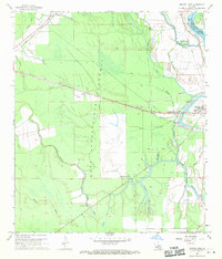
1968 Map of Swayze Lake
USGS Topo · Published 1970About this map
The West Atchafalaya Floodway dominates this mid-century landscape in St. Landry Parish, where a vast network of bayous and lakes manages the overflow of the Atchafalaya River. This environment is shaped by water and transit, defined by the Texas and Pacific railroad cutting diagonally across the terrain through Sambo toward Melville on the eastern bank. The map reveals the intricate drainage patterns of Petite Prairie Bayou, Bad Bayou, and Negro Foot Bayou, alongside significant water bodies like Swayze Lake and Half Moon Lake. Settlement is sparse within the floodway itself, though local life is marked by the United Pentecostal Ch and a Cem near the northern boundary. Industrial and utilitarian footprints appear in the form of multiple pipelines and an Oil Well, while the Hanks Landing Strip and various jeep trails indicate the methods of navigating this bottomland region.
Find a feature on this map
29 named features on this map. Tap any name to fly to it.
Don’t see what you’re looking for? This feature index may not catch every label — zoom into the map to look around manually.
Map Details
Editions of this 1968 Swayze Lake Map
2 editions found
Other maps of this area

1939 · Fordoche
USGS Topo · 1:62,500

1941 · Batchelor
USGS Topo · 1:62,500

1954 · Baton Rouge
USGS Topo · 1:250,000

1955 · Fordoche
USGS Topo · 1:62,500

1955 · Batchelor
USGS Topo · 1:62,500

1955 · Odenburg
USGS Topo · 1:62,500

1956 · Baton Rouge
USGS Topo · 1:250,000

1959 · Fordoche
USGS Topo · 1:62,500

1959 · Palmetto
USGS Topo · 1:62,500

1961 · Baton Rouge
USGS Topo · 1:250,000