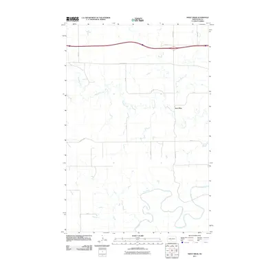
2011 Map of Sweet Briar
USGS Topo · Published 2011About this map
Sweet Briar sits at the center of this rural Morton County landscape, where the meandering course of the Heart River dominates the southern reaches. The terrain is defined by the drainage network of Sweetbriar Creek, which winds northward through a series of section lines and gravel roads. This 2011 survey illustrates the modern agricultural grid of western North Dakota, anchored by major transit corridors like County Rd 83 and 37th Ave. The map provides a clear record of land use at the start of the second decade of the 2000s, showing how local infrastructure like 45th St and County Rd 138 navigates the undulating breaks and coulees typical of this river valley region.
Find a feature on this map
13 named features on this map. Tap any name to fly to it.
Don’t see what you’re looking for? This feature index may not catch every label — zoom into the map to look around manually.
Map Details
Editions of this 2011 Sweet Briar Map
This is the sole edition of this map. No revisions or reprints were ever made.
Other maps of this area

1954 · Bismarck
USGS Topo · 1:250,000

1958 · Bismarck
USGS Topo · 1:250,000

1970 · Judson
USGS Topo · 1:24,000

1970 · New Salem NE
USGS Topo · 1:24,000

1972 · Sweet Briar
USGS Topo · 1:24,000

1972 · Crown Butte Lake
USGS Topo · 1:24,000

1972 · Crown Butte NW
USGS Topo · 1:24,000
1972 · Crown Butte
USGS Topo · 1:24,000

1980 · Green Ridge
USGS Topo · 1:24,000

1980 · Fallon NE
USGS Topo · 1:24,000