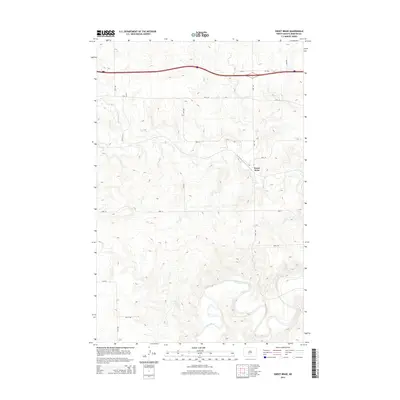
2014 Map of Sweet Briar
USGS Topo · Published 2014About this map
Sweet Briar sits within a landscape defined by the deep meanders of the Heart River and the drainage of Sweetbriar Cr in this 2014 survey. The map reveals the rural grid and topographic character of Morton County, where modern infrastructure like Cr-139a and Lyons Rd intersects with a long-established agricultural layout. The terrain is marked by significant elevation changes, with ridges and valleys falling toward the river bottom. Local mobility is documented through a network of secondary roads such as 45th St Nw and 37th Ave, showing how the modern transportation corridor across the northern section of the map overlays the natural contours of the North Dakota plains. This record is particularly valuable for tracing land use and the persistence of named rural roads in the early 21st century.
Find a feature on this map
16 named features on this map. Tap any name to fly to it.
Don’t see what you’re looking for? This feature index may not catch every label — zoom into the map to look around manually.
Map Details
Editions of this 2014 Sweet Briar Map
This is the sole edition of this map. No revisions or reprints were ever made.
Other maps of this area

1954 · Bismarck
USGS Topo · 1:250,000

1958 · Bismarck
USGS Topo · 1:250,000

1970 · Judson
USGS Topo · 1:24,000

1970 · New Salem NE
USGS Topo · 1:24,000

1972 · Sweet Briar
USGS Topo · 1:24,000

1972 · Crown Butte Lake
USGS Topo · 1:24,000

1972 · Crown Butte NW
USGS Topo · 1:24,000
1972 · Crown Butte
USGS Topo · 1:24,000

1980 · Green Ridge
USGS Topo · 1:24,000

1980 · Fallon NE
USGS Topo · 1:24,000