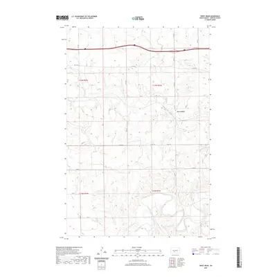
2020 Map of Sweet Briar
USGS Topo · Published 2020About this map
The settlement of Sweet Briar anchors this portion of Morton County, situated where the seasonal drainages of the plains meet a network of rural transit. This modern survey illustrates the persistent layout of the regional landscape, where historic routes like Old Hwy 10 run parallel to the modern interstate corridor. The southern section is dominated by the meandering course of the Heart River, which carves a distinct valley through the prairie, joined from the north by Sweetbriar Cr. The township boundaries of t139n r83w and t138n r83w organize a grid of section roads, including Co Hwy 83 and Lyons Rd, that connect isolated farmsteads and agricultural holdings across the high ground between the river systems.
Find a feature on this map
22 named features on this map. Tap any name to fly to it.
Don’t see what you’re looking for? This feature index may not catch every label — zoom into the map to look around manually.
Map Details
Editions of this 2020 Sweet Briar Map
This is the sole edition of this map. No revisions or reprints were ever made.
Other maps of this area

1954 · Bismarck
USGS Topo · 1:250,000

1958 · Bismarck
USGS Topo · 1:250,000

1970 · Judson
USGS Topo · 1:24,000

1970 · New Salem NE
USGS Topo · 1:24,000

1972 · Sweet Briar
USGS Topo · 1:24,000

1972 · Crown Butte Lake
USGS Topo · 1:24,000

1972 · Crown Butte NW
USGS Topo · 1:24,000
1972 · Crown Butte
USGS Topo · 1:24,000

1980 · Green Ridge
USGS Topo · 1:24,000

1980 · Fallon NE
USGS Topo · 1:24,000