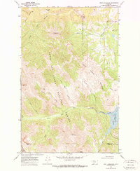
1968 Map of Swift Reservoir
USGS Topo · Published 1972About this map
Lewis and Clark National Forest defines the southern and western portions of this Montana landscape, where the Blackfeet Indian Reservation Boundary cuts across the drainages of Birch Creek and South Fork Whitetail Creek. The map captures the rugged interior of the Front Range before modern development, centered on the Swift Reservoir and its Spillway 4884 at the eastern edge. Notable peaks like Mount Poia and Feather Woman Mountain tower over narrow drainages such as Hungry Man Creek and Haywood Creek. The dramatic geography of the Major Steele Backbone creates a natural divide, while the border between Pondera and Teton Counties runs through the high country near Mount Richmond. This 1968 survey documents the remote water-control infrastructure and traditional boundaries of the Blackfeet lands in a period of relative isolation.
Find a feature on this map
31 named features on this map. Tap any name to fly to it.
Don’t see what you’re looking for? This feature index may not catch every label — zoom into the map to look around manually.
Map Details
Editions of this 1968 Swift Reservoir Map
2 editions found
Other maps of this area

1913 · Marias Pass
USGS Topo · 1:125,000

1914 · Heart Butte
USGS Topo · 1:125,000

1918 · Heart Butte
USGS Topo · 1:125,000

1960 · Cut Bank
USGS Topo · 1:250,000

1963 · Cut Bank
USGS Topo · 1:250,000

1964 · Cut Bank
USGS Topo · 1:250,000

1968 · Half Dome Crag
USGS Topo · 1:24,000

1968 · Swift Reservoir
USGS Topo · 1:24,000
1968 · Gateway Pass
USGS Topo · 1:24,000

1968 · Fish Lake
USGS Topo · 1:24,000