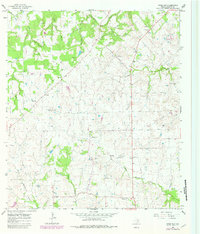
1965 Map of Swiss Alp
USGS Topo · Published 1982About this map
Swiss Alp and the surrounding Fayette County countryside are captured here in a period of rural stability, characterized by small farming communities and a network of named creek branches. The landscape is defined by the headwaters of the East Navidad River and West Navidad River, which drain the rolling terrain north of Freyburg. Local life centers around long-standing landmarks like Trinity Ch and the Philadelphia Ch, while numerous family-named burial grounds including Williams Creek Cem and Kaase Cem provide significant touchpoints for genealogical research. The presence of Roadside Park near Hostyn and numerous Gravel Pits suggests the modest local infrastructure of the mid-1960s. This survey, updated with 1978 aerial data, shows a well-established system of fence lines and unimproved roads connecting small farmsteads and water sources like Lake El-Leo, reflecting the traditional agrarian settlement pattern of this part of Texas.
Find a feature on this map
25 named features on this map. Tap any name to fly to it.
Don’t see what you’re looking for? This feature index may not catch every label — zoom into the map to look around manually.
Map Details
Editions of this 1965 Swiss Alp Map
2 editions found
Other maps of this area

1901 · Flatonia
USGS Topo · 1:125,000

1919 · Schulenburg
USGS Topo · 1:62,500

1953 · Seguin
USGS Topo · 1:250,000

1956 · La Grange
USGS Topo · 1:62,500

1957 · La Grange East
USGS Topo · 1:24,000

1957 · Ammannsville
USGS Topo · 1:24,000

1958 · La Grange West
USGS Topo · 1:24,000
1958 · West Point
USGS Topo · 1:24,000

1958 · Seguin
USGS Topo · 1:250,000

1965 · Muldoon
USGS Topo · 1:24,000