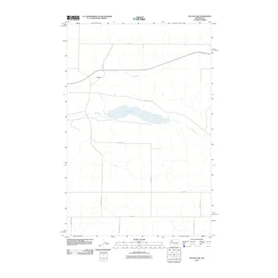
2011 Map of Sylvan Lake
USGS Topo · Published 2011About this map
Sylvan Lake serves as the central focal point of this arid plateau landscape in Lincoln County, where the desert terrain is defined by a sparse but organized network of rural roads. The small settlement of Nemo sits in the northwest, positioned near the intersection of Nemo Rd N and several local thoroughfares. This 2011 survey reveals a landscape shaped by hydrology and family landholdings, with Coal Creek and Crab Creek providing seasonal drainage through the coulees. The road naming conventions, such as Laney Bros Rd E, Hardung Rd E, and Schoonover Rd N, suggest the enduring presence of long-established ranching or farming families in this part of Washington. The grid-like structure of these routes, including Zieler Rd E and Weber Rd E, contrasts with the winding paths of the local creeks.
Find a feature on this map
16 named features on this map. Tap any name to fly to it.
Don’t see what you’re looking for? This feature index may not catch every label — zoom into the map to look around manually.
Map Details
Editions of this 2011 Sylvan Lake Map
This is the sole edition of this map. No revisions or reprints were ever made.
Other maps of this area

1953 · Ritzville
USGS Topo · 1:250,000

1959 · Ritzville
USGS Topo · 1:250,000

1965 · Ritzville
USGS Topo · 1:250,000

1967 · Schoonover
USGS Topo · 1:24,000

1967 · Reiman
USGS Topo · 1:24,000

1967 · Ritzville NW
USGS Topo · 1:24,000

1968 · Sylvan Lake
USGS Topo · 1:24,000

1968 · Coffeepot Lake
USGS Topo · 1:24,000

1968 · Pacific Lake
USGS Topo · 1:24,000
1968 · Odessa
USGS Topo · 1:24,000