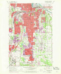
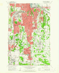
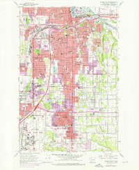
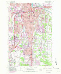
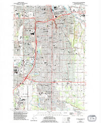
1961 Map of Tacoma South
USGS Topo · Published 1970About this map
The southward expansion of Tacoma is visible here during the early 1960s, a period of significant suburban development defined by the arrival of the Tacoma Mall Shopping Center and the bustling operations at McChord Air Force Base. The urban grid gives way to residential pockets in South Tacoma, Hillsdale, and Fern Hill, while the Puyallup River corridor to the northeast remains an industrial and transit hub near Fife.
Find a feature on this map
118 named features on this map. Tap any name to fly to it.
Don’t see what you’re looking for? This feature index may not catch every label — zoom into the map to look around manually.
Map Details
Editions of this 1961 Tacoma South Map
5 editions found
Other maps of this area

1897 · Tacoma
USGS Topo · 1:125,000

1900 · Tacoma
USGS Topo · 1:125,000

1940 · Anderson Island
USGS Topo · 1:62,500

1941 · Tacoma South
USGS Topo · 1:62,500

1942 · Gig Harbor
USGS Topo · 1:62,500

1943 · Gig Harbor
USGS Topo · 1:62,500

1944 · Tacoma South
USGS Topo · 1:62,500

1948 · Anderson Island
USGS Topo · 1:62,500
1948 · Fort Lewis
USGS Topo · 1:24,000
1948 · Steilacoom
USGS Topo · 1:24,000