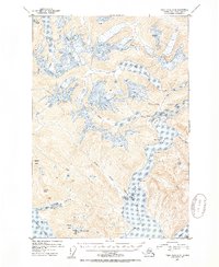
1951 Map of Taku River A-6
USGS Topo · Published 1954About this map
Port Snettisham dominates this 1951 topographical study, providing a look at the glacial landscape southeast of Juneau within the Tongass National Forest. The intricate coastline is marked by deep water entries like Limestone Inlet and Mallard Cove, while the interior is defined by significant elevations such as Everett Peak and Arthur Peak. Resource extraction and maritime navigation are central to the area's identity, evidenced by the Whigg Placer Mine and a Mine (Aband) located near the shoreline. A lone Cabin near the mouth of Crater Creek and a Gaging Sta on the Indian Lake river system point to the isolated human presence here. Large bodies of water like Lake Dorothy and Long Lake sit perched among the peaks, feeding into the complex drainage of the Speel River and Whiting River.
Find a feature on this map
39 named features on this map. Tap any name to fly to it.
Don’t see what you’re looking for? This feature index may not catch every label — zoom into the map to look around manually.
Map Details
Editions of this 1951 Taku River A-6 Map
4 editions found
Other maps of this area

1948 · Sitka D-1
USGS Topo · 1:63,360

1948 · Sumdum D-6
USGS Topo · 1:63,360

1948 · Sumdum D-5
USGS Topo · 1:63,360

1948 · Juneau B-1
USGS Topo · 1:63,360

1951 · Juneau
USGS Topo · 1:250,000

1951 · Taku River B-6
USGS Topo · 1:63,360

1951 · Taku River A-5
USGS Topo · 1:63,360

1951 · Taku River A-6
USGS Topo · 1:63,360

1951 · Taku River B-5
USGS Topo · 1:63,360

1951 · Sitka
USGS Topo · 1:250,000