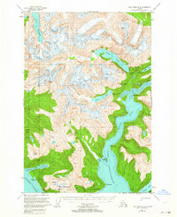
1951 Map of Taku River A-6
USGS Topo · Published 1964About this map
Port Snettisham dominates this 1951 coastal survey, cutting deep into the wilderness of the Tongass National Forest. The dramatic glacial landscape is defined by the Speel Arm and the confluence of the Speel River and Long River. While most of the terrain consists of high summits like Everett Peak and Fillmore Peak, the presence of the Whigg Placer Mine near Mallard Cove highlights the era's ongoing mineral interest in the region. Mapping data from 1948 aerial photography reveals a network of high-altitude water bodies including Lake Dorothy and Crater Lake, which fed the coastal inlets. This sheet captures a critical intersection of maritime passage along Stephens Passage and the industrial potential of the Alaskan interior, evidenced by the Gaging Sta located along the upper river systems.
Find a feature on this map
33 named features on this map. Tap any name to fly to it.
Don’t see what you’re looking for? This feature index may not catch every label — zoom into the map to look around manually.
Map Details
Editions of this 1951 Taku River A-6 Map
4 editions found
Other maps of this area

1948 · Sitka D-1
USGS Topo · 1:63,360

1948 · Sumdum D-6
USGS Topo · 1:63,360

1948 · Sumdum D-5
USGS Topo · 1:63,360

1948 · Juneau B-1
USGS Topo · 1:63,360

1951 · Juneau
USGS Topo · 1:250,000

1951 · Taku River B-6
USGS Topo · 1:63,360

1951 · Taku River A-5
USGS Topo · 1:63,360

1951 · Taku River A-6
USGS Topo · 1:63,360

1951 · Taku River B-5
USGS Topo · 1:63,360

1951 · Sitka
USGS Topo · 1:250,000