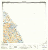
1953 Map of Taku River
USGS Topo · Published 1959About this map
Taku River carves a deep valley through the Coast Mountains, serving as a primary corridor between Alaska and British Columbia in this 1953 compilation. The international boundary is meticulously marked by a series of high-altitude markers, including Boundary Peak 93 and Boundary Peak 87, tracing the crests above the Wright Glacier and Speel Glacier. Human presence is concentrated near the water, with the U S Customs Bldg and Taku Lodge situated along the lower river, while small settlements like Swede and Hubbard dot the coastal fringe. Within the Tongass National Forest, the map reveals a landscape defined by massive ice fields and narrow inlets like Snettisham Port. Genealogists and historians can locate isolated cabins and a Mine near the southern coast, reflecting the mid-century intersection of government oversight and wilderness subsistence in the First Judicial Division.
Find a feature on this map
64 named features on this map. Tap any name to fly to it.
Don’t see what you’re looking for? This feature index may not catch every label — zoom into the map to look around manually.
Map Details
Editions of this 1953 Taku River Map
4 editions found

Other maps of this area

1948 · Sitka D-1
USGS Topo · 1:63,360

1948 · Sumdum D-6
USGS Topo · 1:63,360

1948 · Sumdum D-5
USGS Topo · 1:63,360

1948 · Juneau B-1
USGS Topo · 1:63,360

1949 · Atlin
USGS Topo · 1:250,000

1951 · Juneau
USGS Topo · 1:250,000

1951 · Atlin
USGS Topo · 1:250,000

1951 · Taku River A-4
USGS Topo · 1:63,360

1951 · Taku River B-6
USGS Topo · 1:63,360

1951 · Taku River A-5
USGS Topo · 1:63,360