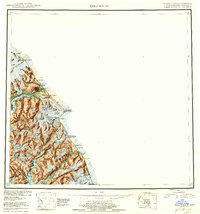
1953 Map of Taku River
USGS Topo · Published 1959About this map
Tongass National Forest dominates the landscape of this mid-century survey, illustrating the complex borderlands where Alaska meets British Columbia. The international boundary is meticulously marked by a series of high-altitude stations, from Boundary Peak 94 in the north down to Mt Hill near the southern edge. Along the coast and river ways, small outposts like Taku Lodge and Hubbard serve as human anchors in a territory of immense glacial systems, including the Twin Glacier and Wright Glacier. The presence of the U S Customs station near Taku Inlet highlights the strategic importance of the Taku River as a corridor for movement between the coast and the interior. Numerous high-altitude lakes, such as Lake Dorothy and Long Lake, are nestled between unnamed peaks, feeding the intricate drainage systems of the Whiting R and Speel River.
Find a feature on this map
60 named features on this map. Tap any name to fly to it.
Don’t see what you’re looking for? This feature index may not catch every label — zoom into the map to look around manually.
Map Details
Editions of this 1953 Taku River Map
4 editions found

Other maps of this area

1948 · Sitka D-1
USGS Topo · 1:63,360

1948 · Sumdum D-6
USGS Topo · 1:63,360

1948 · Sumdum D-5
USGS Topo · 1:63,360

1948 · Juneau B-1
USGS Topo · 1:63,360

1949 · Atlin
USGS Topo · 1:250,000

1951 · Juneau
USGS Topo · 1:250,000

1951 · Atlin
USGS Topo · 1:250,000

1951 · Taku River A-4
USGS Topo · 1:63,360

1951 · Taku River B-6
USGS Topo · 1:63,360

1951 · Taku River A-5
USGS Topo · 1:63,360