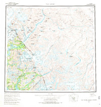
1960 Map of Taku River
USGS Topo · Published 1971About this map
The Taku River corridor serves as the primary artery through this glaciated landscape, where the Alaska British Columbia border cuts across massive ice fields and high peaks. In the lower reaches, the Taku Lodge and a Gaging Station mark the few points of human infrastructure along the river's path into the Tongass National Forest. To the north, the settlement of Tulsequah sits at the confluence of the Tulsequah River, near a noted Mine and the starkly named Hades Highway.
Find a feature on this map
111 named features on this map. Tap any name to fly to it.
Don’t see what you’re looking for? This feature index may not catch every label — zoom into the map to look around manually.
Map Details
Editions of this 1960 Taku River Map
4 editions found

Other maps of this area

1948 · Sitka D-1
USGS Topo · 1:63,360

1948 · Sumdum D-6
USGS Topo · 1:63,360

1948 · Sumdum D-5
USGS Topo · 1:63,360

1948 · Juneau B-1
USGS Topo · 1:63,360

1949 · Atlin
USGS Topo · 1:250,000

1951 · Juneau
USGS Topo · 1:250,000

1951 · Atlin
USGS Topo · 1:250,000

1951 · Taku River A-4
USGS Topo · 1:63,360

1951 · Taku River B-6
USGS Topo · 1:63,360

1951 · Taku River A-5
USGS Topo · 1:63,360