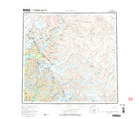
1960 Map of Taku River
USGS Topo · Published 1971About this map
Taku River and its massive glacial systems dominate this mid-century survey of the rugged borderlands between the City and Borough of Juneau and British Columbia. The landscape is defined by the movement of ice and water, from the sprawling Tulsequah Glacier and Wright Glacier to the drainage of the Inklin River across the high Taku Plateau. While the terrain is predominantly wilderness, human presence is noted at Taku Lodge along the lower river and the mountaineering milestone of Camp 4 Peak. Notable peaks like Mount Fremont Morse and Mount Ogden tower over deep valleys and turquoise waters such as Turner Lake and the long expanse of Tatsamenie Lake. The map serves as a detailed record of the international boundary line and the complex hydrology of the Whiting River and Sheslay River systems before modern development.
Find a feature on this map
59 named features on this map. Tap any name to fly to it.
Don’t see what you’re looking for? This feature index may not catch every label — zoom into the map to look around manually.
Map Details
Editions of this 1960 Taku River Map
4 editions found

Other maps of this area

1948 · Sitka D-1
USGS Topo · 1:63,360

1948 · Sumdum D-6
USGS Topo · 1:63,360

1948 · Sumdum D-5
USGS Topo · 1:63,360

1948 · Juneau B-1
USGS Topo · 1:63,360

1949 · Atlin
USGS Topo · 1:250,000

1951 · Juneau
USGS Topo · 1:250,000

1951 · Atlin
USGS Topo · 1:250,000

1951 · Taku River A-4
USGS Topo · 1:63,360

1951 · Taku River B-6
USGS Topo · 1:63,360

1951 · Taku River A-5
USGS Topo · 1:63,360