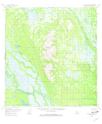
1954 Map of Talkeetna A-3
USGS Topo · Published 1980About this map
Mount Yenlo and the surrounding Yenlo Hills dominate this portion of the Matanuska-Susitna region, rising above a complex network of waterways and wetlands. The drainage pattern is defined by the broad Yentna River in the south and the meandering Lake Creek to the east. The landscape's low-lying areas are characterized by numerous water bodies like Hewitt Lake, Donkey Creek Lake, and Shovel Lake, alongside unnamed sloughs and marshlands. Evidence of human presence is sparse, limited to an occasional Cabin tucked near the base of Willow Mountain or along the riverbanks. This 1954 survey, with minor revisions through 1979, illustrates a wilderness area where transportation is governed by water and elevation rather than roads, providing a clear record of the terrain as it existed before significant modern encroachment.
Find a feature on this map
14 named features on this map. Tap any name to fly to it.
Don’t see what you’re looking for? This feature index may not catch every label — zoom into the map to look around manually.
Map Details
Editions of this 1954 Talkeetna A-3 Map
3 editions found
Other maps of this area

1949 · Tyonek
USGS Topo · 1:250,000

1950 · Talkeetna
USGS Topo · 1:250,000

1951 · Talkeetna
USGS Topo · 1:250,000

1951 · Tyonek
USGS Topo · 1:250,000

1954 · Tyonek D-3
USGS Topo · 1:63,360

1954 · Talkeetna A-3
USGS Topo · 1:63,360

1954 · Tyonek D-5
USGS Topo · 1:63,360

1954 · Tyonek D-4
USGS Topo · 1:63,360

1954 · Talkeetna B-4
USGS Topo · 1:63,360

1954 · Talkeetna A-2
USGS Topo · 1:63,360