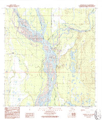
1987 Map of Talkeetna B-1 SE
USGS Topo · Published 1987About this map
Talkeetna sits at the critical confluence of three major glacial river systems, serving as a vital transportation hub for the interior. The braided channels of the Susitna River, Chulitna River, and Talkeetna River dominate the landscape, illustrating the dynamic nature of Alaskan waterways before the heavy influence of modern engineering. The presence of The Alaska Railroad and the Airport highlights the town's role as a departure point for northern expeditions. To the west, the settlement of Trapper Creek is linked by the Petersville Road, while a Winter Trail suggests the seasonal routes necessary for traversing this environment. Local life is anchored by landmarks such as the Talkeetna Lakes, a Campground, and a small Cem, reflecting a frontier community shaped by its proximity to the water and the rising Bartlett Hills.
Find a feature on this map
27 named features on this map. Tap any name to fly to it.
Don’t see what you’re looking for? This feature index may not catch every label — zoom into the map to look around manually.
Map Details
Editions of this 1987 Talkeetna B-1 SE Map
2 editions found
Other maps of this area

1949 · Talkeetna Mountains B-6
USGS Topo · 1:63,360

1950 · Talkeetna Mountains
USGS Topo · 1:250,000

1950 · Talkeetna
USGS Topo · 1:250,000

1950 · Talkeetna Mountains A-6
USGS Topo · 1:63,360

1951 · Talkeetna
USGS Topo · 1:250,000

1951 · Talkeetna B-1
USGS Topo · 1:63,360

1952 · Talkeetna Mountains B-6
USGS Topo · 1:63,360

1952 · Talkeetna A-1
USGS Topo · 1:63,360
1952 · Talkeetna Mountains A-6
USGS Topo · 1:63,360

1954 · Talkeetna Mountains
USGS Topo · 1:250,000