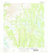
1954 Map of Talkeetna B-2
USGS Topo · Published 1969About this map
Dredge Tailings in the northern reaches of this territory indicate an era of active mineral extraction, particularly near the confluence of Cache Creek and Wilson Creek. The landscape is dominated by the Peters Hills and Little Peters Creek, where the terrain transitions into a complex network of wetlands and small water bodies. Notable among these are the curiously named Lake Lake and Twentyfive Mile Lake.
Find a feature on this map
29 named features on this map. Tap any name to fly to it.
Don’t see what you’re looking for? This feature index may not catch every label — zoom into the map to look around manually.
Map Details
Editions of this 1954 Talkeetna B-2 Map
3 editions found
Other maps of this area

1950 · Talkeetna
USGS Topo · 1:250,000

1951 · Talkeetna
USGS Topo · 1:250,000

1951 · Talkeetna B-1
USGS Topo · 1:63,360

1951 · Talkeetna C-1
USGS Topo · 1:63,360

1952 · Talkeetna A-1
USGS Topo · 1:63,360

1954 · Talkeetna A-3
USGS Topo · 1:63,360

1954 · Talkeetna A-2
USGS Topo · 1:63,360

1954 · Talkeetna B-3
USGS Topo · 1:63,360

1954 · Talkeetna B-2
USGS Topo · 1:63,360

1958 · Talkeetna B-1
USGS Topo · 1:63,360