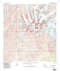
1958 Map of Talkeetna B-6
USGS Topo · Published 1986About this map
Cathedral Spires dominate the central landscape of this 1958 survey, marking a dramatic intersection of ice and granite within the Kichatna Mountains. This remote interior region, later designated as part of the Denali National Preserve, is defined by a massive glacial network where the Tatina Glacier and Cul-de-sac Glacier flow between high-altitude summits like Kichatna Spire and Gurney Peak. The drainage patterns here are dictated by these ice fields, feeding the Kichatna River to the south and the Tatina River to the west. Evidence of the challenging terrain is found at Simpson Pass, one of the few named terrestrial crossings in a quadrangle otherwise characterized by complex glaciers such as Shelf Glacier and Shadows Glacier. The map records this Alaskan wilderness shortly after aerial photogrammetric methods allowed for the precise mapping of its many unnamed cirques and tributary creeks, including Morris Creek and Threemile Creek.
Find a feature on this map
21 named features on this map. Tap any name to fly to it.
Don’t see what you’re looking for? This feature index may not catch every label — zoom into the map to look around manually.
Map Details
Editions of this 1958 Talkeetna B-6 Map
3 editions found
Other maps of this area

1949 · McGrath
USGS Topo · 1:250,000

1950 · McGrath
USGS Topo · 1:250,000

1950 · Talkeetna
USGS Topo · 1:250,000

1951 · Talkeetna
USGS Topo · 1:250,000

1958 · Talkeetna A-6
USGS Topo · 1:63,360

1958 · Talkeetna A-5
USGS Topo · 1:63,360

1958 · Talkeetna B-5
USGS Topo · 1:63,360

1958 · Talkeetna B-6
USGS Topo · 1:63,360

1958 · Talkeetna C-6
USGS Topo · 1:63,360

1958 · McGrath B-1
USGS Topo · 1:63,360