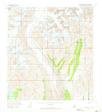
1958 Map of Talkeetna C-3
USGS Topo · Published 1972About this map
The massive Kahiltna Glacier dominates the central landscape of this mid-century survey, flanked by the Dutch Hills to the southeast. This portion of the Matanuska-Susitna region reveals a classic glacial environment where high-altitude ice fields like Lacuna Glacier and Kanikula Glacier feed a network of meltwater streams. The presence of a Landing Strip, several cabins, and a Mine near Dollar Creek indicates the seasonal push of prospecting and aviation into the Alaskan wilderness during the 1950s. A primitive Tractor Trail provides a glimpse into the difficult logistics of the era, winding through the hills near Stone Creek and Whistler Creek. The southwestern corner is anchored by the expanse of Chelatna Lake, where Coffee Creek enters from the surrounding slopes, marking a transition from the ice-choked valleys to more accessible terrain.
Find a feature on this map
21 named features on this map. Tap any name to fly to it.
Don’t see what you’re looking for? This feature index may not catch every label — zoom into the map to look around manually.
Map Details
Editions of this 1958 Talkeetna C-3 Map
3 editions found
Other maps of this area

1950 · Talkeetna
USGS Topo · 1:250,000

1951 · Talkeetna
USGS Topo · 1:250,000

1954 · Talkeetna B-4
USGS Topo · 1:63,360

1954 · Talkeetna B-3
USGS Topo · 1:63,360

1954 · Talkeetna B-2
USGS Topo · 1:63,360

1958 · Talkeetna C-4
USGS Topo · 1:63,360

1958 · Talkeetna C-2
USGS Topo · 1:63,360

1958 · Talkeetna D-4
USGS Topo · 1:63,360

1958 · Talkeetna D-2
USGS Topo · 1:63,360

1958 · Talkeetna C-3
USGS Topo · 1:63,360