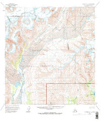
1958 Map of Talkeetna C-4
USGS Topo · Published 1995About this map
Dall Glacier and the Yentna Glacier dominate this glacial landscape within the Denali National Park and Denali National Preserve. The 1950s survey captures the intricate drainage patterns of the East Fork Yentna River as it winds through glacial valleys. Smaller tributaries such as Idaho Creek, California Creek, and Colorado Creek cut through the southeastern terrain, feeding toward the Chelatna Lake area. The presence of features like Sunflower Basin and Stern Gulch indicates a landscape shaped by significant ice movements and seasonal runoff. The map clearly delineates the administrative boundary between the Denali Borough and Matanuska-Susitna Borough, providing a precise look at the geography before modern infrastructure or significant human expansion altered these remote corridors.
Find a feature on this map
19 named features on this map. Tap any name to fly to it.
Don’t see what you’re looking for? This feature index may not catch every label — zoom into the map to look around manually.
Map Details
Editions of this 1958 Talkeetna C-4 Map
3 editions found
Other maps of this area

1950 · Talkeetna
USGS Topo · 1:250,000

1951 · Talkeetna
USGS Topo · 1:250,000

1954 · Talkeetna B-4
USGS Topo · 1:63,360

1954 · Talkeetna B-3
USGS Topo · 1:63,360

1958 · Talkeetna B-5
USGS Topo · 1:63,360

1958 · Talkeetna D-5
USGS Topo · 1:63,360

1958 · Talkeetna C-4
USGS Topo · 1:63,360

1958 · Talkeetna D-4
USGS Topo · 1:63,360

1958 · Talkeetna C-3
USGS Topo · 1:63,360

1958 · Talkeetna D-3
USGS Topo · 1:63,360