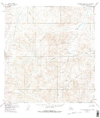
1951 Map of Talkeetna Mountains A-2
USGS Topo · Published 1975About this map
The Oshetna River and Little Oshetna River carve through a high-altitude landscape in this 1951 record of the Matanuska-Susitna region. This survey, based on 1949 aerial photography, documents a terrain dominated by watercourses and mountain passes before modern infrastructure altered the subarctic wilderness. The southern portion of the map is defined by the Horn Mountains and the Limestone Hills, where the prominent Limestone Gap provides a natural corridor between drainages. Notable geological and paleontological references appear in the naming of Cardioceras Creek and Cadoceras Creek, while the curious label Nowhere marks a specific point in the northwestern corner. The map traces the intricate headwaters of the Little Nelchina River and Caribou Creek, reflecting the remote surveying efforts of the era.
Find a feature on this map
27 named features on this map. Tap any name to fly to it.
Don’t see what you’re looking for? This feature index may not catch every label — zoom into the map to look around manually.
Map Details
Editions of this 1951 Talkeetna Mountains A-2 Map
3 editions found
Other maps of this area

1948 · Anchorage D-3
USGS Topo · 1:63,360

1948 · Anchorage D-2
USGS Topo · 1:63,360

1949 · Talkeetna Mountains A-1
USGS Topo · 1:63,360

1950 · Talkeetna Mountains
USGS Topo · 1:250,000

1951 · Anchorage
USGS Topo · 1:250,000

1951 · Talkeetna Mountains B-1
USGS Topo · 1:63,360

1951 · Talkeetna Mountains A-2
USGS Topo · 1:63,360

1951 · Talkeetna Mountains B-3
USGS Topo · 1:63,360

1951 · Talkeetna Mountains A-3
USGS Topo · 1:63,360

1951 · Talkeetna Mountains B-2
USGS Topo · 1:63,360