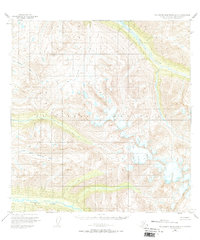
1950 Map of Talkeetna Mountains A-5
USGS Topo · Published 1973About this map
The Talkeetna Mountains dominate this high-elevation terrain in the Matanuska-Susitna region, mapped just after the mid-century from 1949 aerial photography. This landscape is defined by the complex drainage systems of the Sheep River and the Kashwitna River, which carve through the peaks. To the south, the North Fork Kashwitna River marks a primary watershed boundary, while the northern slopes feed the S Fk Montana Creek. Topographical survey points like VABM Brownie and VABM Sheep Honey provide essential elevation data in a territory without established roads or permanent settlements at the time of the 1950 field annotation. The arrangement of the Sheep Creek and its neighboring tributaries reveals a wilderness defined entirely by its natural hydrology and alpine relief.
Find a feature on this map
8 named features on this map. Tap any name to fly to it.
Don’t see what you’re looking for? This feature index may not catch every label — zoom into the map to look around manually.
Map Details
Editions of this 1950 Talkeetna Mountains A-5 Map
3 editions found
Other maps of this area

1949 · Anchorage D-7
USGS Topo · 1:63,360

1949 · Talkeetna Mountains B-6
USGS Topo · 1:63,360

1949 · Talkeetna Mountains A-4
USGS Topo · 1:63,360

1950 · Talkeetna Mountains
USGS Topo · 1:250,000

1950 · Talkeetna Mountains B-5
USGS Topo · 1:63,360

1950 · Talkeetna Mountains B-4
USGS Topo · 1:63,360

1950 · Anchorage D-6
USGS Topo · 1:63,360

1950 · Talkeetna Mountains A-6
USGS Topo · 1:63,360

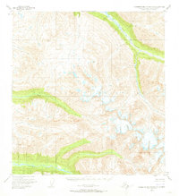
1950 · Talkeetna Mountains A-5
USGS Topo · 1:63,360

1951 · Anchorage
USGS Topo · 1:250,000