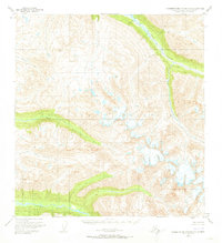
1950 Map of Talkeetna Mountains A-5
USGS Topo · Published 1973About this map
The Talkeetna Mountains dominate this 1950s survey of the Matanuska-Susitna region, revealing a landscape defined by glacial activity and high alpine drainage systems. The Kashwitna River and its North Fork Kashwitna River carve deep valleys through the southern portion of the sheet, while the Sheep River provides a primary arterial corridor through the northeast. At this mid-century moment, the area remains largely untouched by permanent settlement, with land lines representing unsurveyed locations predetermined by the Bureau of Land Management. The intricate contour work illustrates the steep transitions from river basins to high peaks, particularly around Sheep Creek and the headwaters of S Fk Montana Creek. This map is an essential reference for understanding the hydrography and primary natural landmarks of the region before modern infrastructure began to alter the accessibility of the Alaskan interior.
Find a feature on this map
6 named features on this map. Tap any name to fly to it.
Don’t see what you’re looking for? This feature index may not catch every label — zoom into the map to look around manually.
Map Details
Editions of this 1950 Talkeetna Mountains A-5 Map
3 editions found
Other maps of this area

1949 · Anchorage D-7
USGS Topo · 1:63,360

1949 · Talkeetna Mountains B-6
USGS Topo · 1:63,360

1949 · Talkeetna Mountains A-4
USGS Topo · 1:63,360

1950 · Talkeetna Mountains
USGS Topo · 1:250,000

1950 · Talkeetna Mountains B-5
USGS Topo · 1:63,360

1950 · Talkeetna Mountains B-4
USGS Topo · 1:63,360

1950 · Anchorage D-6
USGS Topo · 1:63,360

1950 · Talkeetna Mountains A-6
USGS Topo · 1:63,360

1950 · Talkeetna Mountains A-5
USGS Topo · 1:63,360

1951 · Anchorage
USGS Topo · 1:250,000