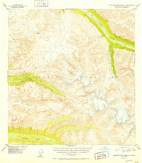
1952 Map of Talkeetna Mountains A-5
USGS Topo · Published 1952About this map
The Kashwitna River and the Sheep River define the glacial drainage patterns across this high-altitude Alaskan landscape in the early 1950s. Surveyed shortly after World War II using aerial photographs taken in 1949, the map reveals a wilderness shaped by massive relief and dramatic elevation changes. The braided channels of the North Fork Kashwitna River cut through the lower elevations, while the higher peaks are marked by precise geodetic control points such as VABM 5595 Honey and VABM 4792 Brownie. These survey markers are critical for understanding the mapping of the Talkeetna Mountains during a period of intense USGS activity in the territory. Smaller drainages like Montana Creek and Sheep Creek thread through the complex topography, illustrating the watershed before modern development reached this portion of the interior.
Find a feature on this map
8 named features on this map. Tap any name to fly to it.
Don’t see what you’re looking for? This feature index may not catch every label — zoom into the map to look around manually.
Map Details
Editions of this 1952 Talkeetna Mountains A-5 Map
2 editions found
Other maps of this area

1949 · Anchorage D-7
USGS Topo · 1:63,360

1949 · Talkeetna Mountains B-6
USGS Topo · 1:63,360

1949 · Talkeetna Mountains A-4
USGS Topo · 1:63,360

1950 · Talkeetna Mountains
USGS Topo · 1:250,000

1950 · Talkeetna Mountains B-5
USGS Topo · 1:63,360

1950 · Talkeetna Mountains B-4
USGS Topo · 1:63,360

1950 · Anchorage D-6
USGS Topo · 1:63,360

1950 · Talkeetna Mountains A-6
USGS Topo · 1:63,360

1950 · Talkeetna Mountains A-5
USGS Topo · 1:63,360

1951 · Anchorage
USGS Topo · 1:250,000