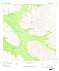
1950 Map of Talkeetna Mountains B-5
USGS Topo · Published 1970About this map
Talkeetna River and Sheep River dominate this interior Alaskan landscape, their braided channels cutting through the towering Talkeetna Mountains. This 1950s era survey captures a wilderness largely devoid of roads, where the only sign of habitation is a lone Cabin located near the East Fork of Iron Creek. The topography is defined by significant elevations like Wells Mountain and various triangulation stations, including Vabm 5711 Junto and Vabm 4114 Disappointment. High-altitude water bodies such as Rainbow Lake and the Diana Lakes are prominent features amidst the complex drainage systems of Hyphen Gulch and Prospect Creek. The map provides a detailed look at the Seward Meridian as it passes through this glaciated terrain, offering a clear record of the region's hydrological and geological structure before modern development.
Find a feature on this map
17 named features on this map. Tap any name to fly to it.
Don’t see what you’re looking for? This feature index may not catch every label — zoom into the map to look around manually.
Map Details
Editions of this 1950 Talkeetna Mountains B-5 Map
3 editions found
Other maps of this area

1949 · Talkeetna Mountains B-6
USGS Topo · 1:63,360

1949 · Talkeetna Mountains C-6
USGS Topo · 1:63,360

1949 · Talkeetna Mountains A-4
USGS Topo · 1:63,360

1950 · Talkeetna Mountains
USGS Topo · 1:250,000

1950 · Talkeetna Mountains B-5
USGS Topo · 1:63,360

1950 · Talkeetna Mountains B-4
USGS Topo · 1:63,360

1950 · Talkeetna Mountains A-6
USGS Topo · 1:63,360

1950 · Talkeetna Mountains A-5
USGS Topo · 1:63,360

1950 · Talkeetna Mountains C-5
USGS Topo · 1:63,360

1951 · Talkeetna Mountains C-4
USGS Topo · 1:63,360