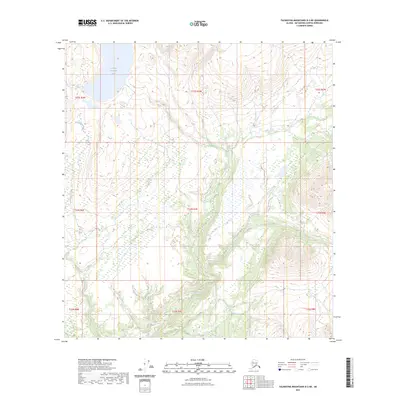
2023 Map of Talkeetna Mountains D-3 NE
USGS Topo · Published 2023About this map
Lowland Kacaugh Lake dominates the northern high country of this interior landscape, where the drainage systems of Delusion Creek and Watana Creek carve through the Matanuska-Susitna Borough. This 2023 survey by the U.S. Geological Survey illustrates a wilderness defined by its hydrologic patterns rather than human settlements, highlighting the complex township and range divisions such as t33n r7e and t22s r3w. The map provides a contemporary record of the shifting wetland boundaries and elevation data that shape this subarctic terrain, serving as an essential reference for understanding the remote topography between the Talkeetna and Susitna basins.
Find a feature on this map
12 named features on this map. Tap any name to fly to it.
Don’t see what you’re looking for? This feature index may not catch every label — zoom into the map to look around manually.
Map Details
Editions of this 2023 Talkeetna Mountains D-3 NE Map
This is the sole edition of this map. No revisions or reprints were ever made.
Other maps of this area

1950 · Talkeetna Mountains
USGS Topo · 1:250,000

1950 · Healy A-3
USGS Topo · 1:63,360

1951 · Healy
USGS Topo · 1:250,000

1951 · Talkeetna Mountains D-2
USGS Topo · 1:63,360

1951 · Talkeetna Mountains D-3
USGS Topo · 1:63,360

1951 · Healy A-2
USGS Topo · 1:63,360
1952 · Healy A-3
USGS Topo · 1:63,360

1952 · Healy A-2
USGS Topo · 1:63,360
1952 · Talkeetna Mountains D-2
USGS Topo · 1:63,360
1953 · Talkeetna Mountains D-3
USGS Topo · 1:63,360