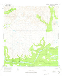
1951 Map of Talkeetna Mountains D-4
USGS Topo · Published 1975About this map
The Susitna River carves a massive glacial corridor through this wilderness as it appeared in the early 1950s. This survey, based on 1949 aerial photography and field-annotated in 1951, documents a raw landscape dominated by high-altitude plateaus and drainage networks. The northern reaches are defined by the South Boundary Fairbanks Meridian, where Portage Creek and Devil Creek descend toward the main river valley. Prominent terrain features like Tsusena Butte and the geodetic marker at VABM 3780 Devil serve as critical landmarks in a region lacking any established roads or trails at the time of mapping. To the southeast, the Fog Lakes and Fog Creek system illustrates the complex hydrology of the Talkeetna backcountry before modern development or intensive resource exploration reached this sector of the Matanuska-Susitna region.
Find a feature on this map
10 named features on this map. Tap any name to fly to it.
Don’t see what you’re looking for? This feature index may not catch every label — zoom into the map to look around manually.
Map Details
Editions of this 1951 Talkeetna Mountains D-4 Map
3 editions found

Other maps of this area

1950 · Talkeetna Mountains
USGS Topo · 1:250,000

1950 · Talkeetna Mountains D-5
USGS Topo · 1:63,360

1950 · Healy A-3
USGS Topo · 1:63,360

1950 · Healy A-4
USGS Topo · 1:63,360

1950 · Healy A-5
USGS Topo · 1:63,360

1950 · Talkeetna Mountains C-5
USGS Topo · 1:63,360

1951 · Healy
USGS Topo · 1:250,000

1951 · Talkeetna Mountains D-5
USGS Topo · 1:63,360

1951 · Talkeetna Mountains C-4
USGS Topo · 1:63,360

1951 · Talkeetna Mountains D-3
USGS Topo · 1:63,360