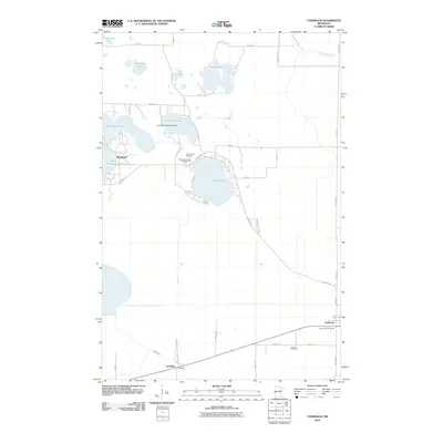
2010 Map of Tamarack
USGS Topo · Published 2010About this map
Lake Minnewawa and Big Sandy Lake anchor a landscape defined by significant water bodies and protected marshlands in northern Minnesota. This 2010 survey reveals the lakeside settlement of Sheshebee and the transportation hub of Tamarack, where the Tamarack Post Office serves the local community. The distribution of lakes, including Round Lake, Anderson Lake, and Island Lake, illustrates the glacial geography of Aitkin County, while the Grayling Wildlife Management area and Savanna State First indicate a commitment to conservation. The map highlights specialized infrastructure like the Kivi-Mokki Seaplane Base on Horseshoe Lake, reflecting the region's reliance on air and water travel. Researchers can identify local landmarks such as Round Lake Cemetery and Fairview Cemetery, alongside the small rail-adjacent settlement of Grayling near the Sandy River.
Find a feature on this map
38 named features on this map. Tap any name to fly to it.
Don’t see what you’re looking for? This feature index may not catch every label — zoom into the map to look around manually.
Map Details
Editions of this 2010 Tamarack Map
This is the sole edition of this map. No revisions or reprints were ever made.
Other maps of this area

1953 · Duluth
USGS Topo · 1:250,000

1958 · Duluth
USGS Topo · 1:250,000

1969 · Automba
USGS Topo · 1:24,000

1969 · Lawler
USGS Topo · 1:24,000

1970 · Mc Gregor
USGS Topo · 1:24,000

1970 · Tamarack
USGS Topo · 1:24,000

1970 · Little Prairie Lake
USGS Topo · 1:24,000

1970 · Balsam
USGS Topo · 1:24,000

1970 · Libby
USGS Topo · 1:24,000

1970 · Wright
USGS Topo · 1:24,000