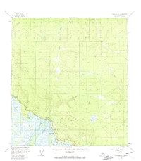
1955 Map of Tanacross A-2
USGS Topo · Published 1974About this map
The Nabesna River and Chisana River converge in this mid-century survey to form the Tanana River, creating a landscape defined by braided waterways and low-lying wetlands. Human activity is concentrated along the Alaska Highway corridor, where the settlements of Northway Junction and the Northway Motel serve as key stops for travelers and transport. The presence of an Above Ground Pipeline and nearby Oil Tanks underscores the strategic and industrial infrastructure of the era, while a Radio Tower marks a rare vertical landmark in the basin. Further north, the terrain rises into Cheneathda Hill and the headwaters of the South Fork Ladue River. Scattered Gravel Pits and the Beaver Creek Roadhouse illustrate the practical requirements of maintainance and lodging in this part of the Alaska interior during the 1950s.
Find a feature on this map
24 named features on this map. Tap any name to fly to it.
Don’t see what you’re looking for? This feature index may not catch every label — zoom into the map to look around manually.
Map Details
Editions of this 1955 Tanacross A-2 Map
2 editions found

Other maps of this area

1948 · Tanacross A-3
USGS Topo · 1:63,360

1948 · Tanacross B-3
USGS Topo · 1:63,360

1949 · Tanacross
USGS Topo · 1:250,000

1949 · Tanacross B-3
USGS Topo · 1:63,360

1950 · Tanacross
USGS Topo · 1:250,000

1950 · Nabesna
USGS Topo · 1:250,000

1951 · Nabesna
USGS Topo · 1:250,000

1952 · Tanacross A-3
USGS Topo · 1:63,360

1952 · Tanacross B-3
USGS Topo · 1:63,360

1952 · Nabesna D-1
USGS Topo · 1:63,360