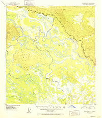
1952 Map of Tanacross A-3
USGS Topo · Published 1952About this map
The Tetlin Indian Reservation occupies the center of this landscape, its boundary following the winding course of the Tanana River and the complex wetlands of the upper Tanana valley. Mapped by the Geological Survey from 1948 aerial photography, the region is defined by a dense network of water, including the Tetlin River, Kalutna River, and Midway Lake. The northern edge is traced by the Alaska Highway, which runs along the base of the hills, providing a vital transport corridor past scattered Cabins. This survey documents a critical period of post-war infrastructure development in the Alaskan interior, showing the intersection of traditional land use and the modern road network against the backdrop of Chisana Mountain.
Find a feature on this map
15 named features on this map. Tap any name to fly to it.
Don’t see what you’re looking for? This feature index may not catch every label — zoom into the map to look around manually.
Map Details
Editions of this 1952 Tanacross A-3 Map
2 editions found

Other maps of this area

1948 · Tanacross A-3
USGS Topo · 1:63,360

1948 · Tanacross A-4
USGS Topo · 1:63,360

1948 · Tanacross B-3
USGS Topo · 1:63,360

1949 · Tanacross
USGS Topo · 1:250,000

1949 · Tanacross B-4
USGS Topo · 1:63,360

1949 · Tanacross B-3
USGS Topo · 1:63,360

1950 · Tanacross
USGS Topo · 1:250,000

1950 · Nabesna
USGS Topo · 1:250,000

1951 · Nabesna
USGS Topo · 1:250,000

1951 · Tanacross B-4
USGS Topo · 1:63,360