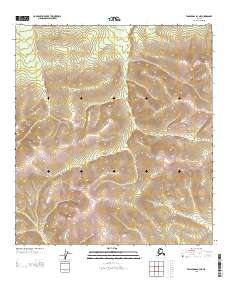
2013 Map of Tanacross B-3 NE
USGS Topo · Published 2013About this map
High elevations and steep contour lines dominate this interior Alaskan landscape, which is marked by very few human-made features. In the northwest corner, the Winter Trl cuts across the terrain, representing a vital seasonal passage through the backcountry. This 2013 survey illustrates the vast, undeveloped character of the Southeast Fairbanks area, where the environment is defined almost entirely by the rising and falling of the land rather than by permanent settlements. The presence of the winter route suggests the local reliance on frozen ground and snowpack for travel in regions where traditional year-round roads are absent.
Find a feature on this map
5 named features on this map. Tap any name to fly to it.
Don’t see what you’re looking for? This feature index may not catch every label — zoom into the map to look around manually.
Map Details
Editions of this 2013 Tanacross B-3 NE Map
This is the sole edition of this map. No revisions or reprints were ever made.
Other maps of this area

1948 · Tanacross B-3
USGS Topo · 1:63,360

1949 · Tanacross
USGS Topo · 1:250,000

1949 · Tanacross B-3
USGS Topo · 1:63,360

1950 · Tanacross
USGS Topo · 1:250,000

1952 · Tanacross B-3
USGS Topo · 1:63,360

1956 · Tanacross C-3
USGS Topo · 1:63,360

1956 · Tanacross C-2
USGS Topo · 1:63,360
1956 · Tanacross B-2
USGS Topo · 1:63,360

1956 · Tanacross
USGS Topo · 1:250,000

1964 · Tanacross
USGS Topo · 1:250,000